Exodus from Egypt
19,00 €
- Description
Description
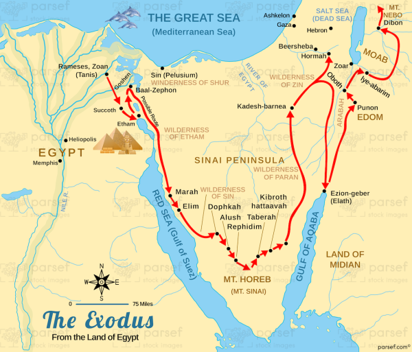
The stock image depicts the route taken by the Israelites as they fled slavery in Egypt and journeyed towards the promised land of Canaan. The map is rendered in a muted color scheme, with major cities and landmarks marked in black.
The map shows the starting point of the Israelites’ journey in the Nile Delta region of Egypt, near the city of Ramses. It then shows the route they took as they traveled through the Sinai Peninsula towards the Red Sea. The path of the Israelites is marked with a dotted line, which winds its way through the desert terrain.
The Red Sea is prominently featured on the map, along with the location of the miracle of the parting of the sea, which allowed the Israelites to escape from the pursuing Egyptian army. The map also shows the location of Mount Sinai, where Moses received the Ten Commandments from God.
As the Israelites journeyed towards the promised land, they encountered various challenges and obstacles, which are depicted on the map. These include the oasis of Elim, where they found water, and the site of the golden calf, where they fell into idolatry.
Overall, the stock image provides a detailed and visually engaging representation of the route taken by the Israelites as they fled from slavery in Egypt and journeyed towards the promised land of Canaan. It is a useful resource for historians, educators, and anyone interested in the rich history of the Israelites in the ancient Near East.


