
Israel in Old Testament Times
19,00 €
- Description
Description
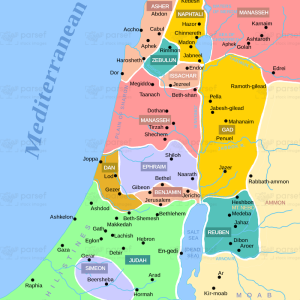
The stock image depicts the land of Israel during the period of the Old Testament, from the time of Abraham to the Babylonian exile. The map shows the various regions and territories within Israel, including Galilee, Samaria, Judea, and the Negev Desert.
It also displays the major bodies of water in the region, such as the Mediterranean Sea, the Sea of Galilee, and the Dead Sea. The map also highlights the major cities and towns of the time, including Jerusalem, Jericho, Bethlehem, Nazareth, and others.
Additionally, the map shows the major routes and trade routes that were used in ancient Israel, including the Via Maris, the King’s Highway, and the Way of the Patriarchs.
The stock image provides a comprehensive and detailed overview of the geography and topography of ancient Israel, and it serves as an important resource for understanding the historical and cultural context of the Old Testament.
One Year License.
For personal, church or classroom use only.
Related products
-
 Add to cartQuick View
 -
 Add to cartQuick View
 -
 Add to cartQuick View
 -
Add to cartQuick View
-
Add to cartQuick View
-
HotAdd to cartQuick View
-
Add to cartQuick View
-
Add to cartQuick View
-
 Add to cartQuick View
 -
Add to cartQuick View