Ancient World of Genesis
18,00 €
- Description
Description
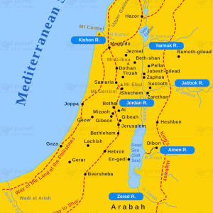
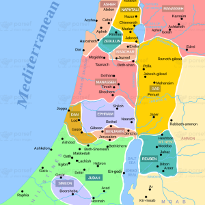
The stock image is a historical illustration of the region that was known to exist during the events described in the Book of Genesis in the Bible. The map features a parchment-style background, with intricate illustrations of the geography, major cities, and important landmarks of the region.
The map depicts the Ancient World of Genesis as a vast and diverse region that encompasses modern-day Israel, Egypt, Iraq, Iran, and parts of Turkey and Saudi Arabia. The different regions, such as Mesopotamia, the Levant, and Egypt, are marked with distinct colors and shading, making them easy to identify on the map.
The major cities of the Ancient World of Genesis, such as Babylon, Ur, and Jerusalem, are marked with prominent symbols and bold lettering, indicating their importance to the people and events described in the Book of Genesis. Other important landmarks, such as the Tigris and Euphrates rivers, the Red Sea, and the Dead Sea, are also illustrated on the map.
The map provides a clear view of the extensive land and sea routes that connected the various regions of the Ancient World of Genesis, allowing for trade, communication, and movement of people and goods. These routes are marked with distinct symbols and colors, making it easy to understand the importance of these transportation systems.
Additionally, the map provides a legend that explains the different symbols and colors used to represent the various features of the map, including the different regions, cities, and important landmarks.
Overall, the stock image is a fascinating and informative illustration of the region that was known to exist during the events described in the Bible. The detailed illustrations and clear labeling make it a valuable resource for historians, scholars, and anyone interested in the history of the Ancient World and the Bible.