Captivity of the 10 Tribes
17,00 €
- Description
Description
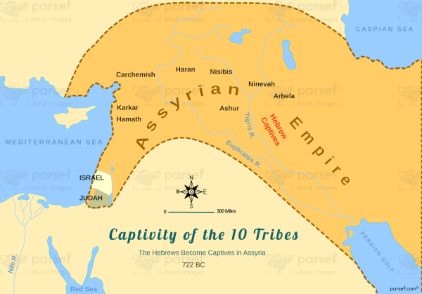
The stock image depicts the region of Israel during the period of the Assyrian conquest and the subsequent exile of the ten northern tribes of Israel. The map is rendered in a muted color scheme, with the different regions and territories marked in different colors for clarity.
The map shows the region of Israel as it was known during the eighth century BCE, highlighting the territories of the different tribes of Israel, including Ephraim, Manasseh, and Reuben. It also shows the different regions and territories of the neighboring kingdoms, including the Kingdom of Judah to the south and the Kingdom of Assyria to the north and east.
The map depicts the route of the Assyrian army as it advanced through Israel, conquering the cities and towns along the way. It also shows the location of the different Israelite cities and towns that were destroyed or captured by the Assyrians, such as Samaria, the capital of the northern kingdom of Israel.
The map also highlights the various locations where the Israelite captives were resettled by the Assyrians, including various parts of the Assyrian Empire and the region of Media. This event became known as the “captivity of the ten tribes” and was a significant event in the history of ancient Israel.
Overall, the stock image provides a clear and visually engaging representation of the events surrounding the Assyrian conquest of Israel and the exile of the ten northern tribes, and is a useful resource for historians, educators, and anyone interested in the rich history and culture of the region.


