Israel and Judah During Hosea’s Time
18,00 €
- Description
Description
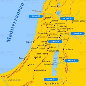
The stock image depicts the geographic regions of Israel and Judah during the time of the prophet Hosea, as described in the Old Testament. The map shows the northern kingdom of Israel and the southern kingdom of Judah, with the major cities, rivers, and natural features of the area. The map also includes the neighboring nations of Assyria and Egypt, which were significant players in the political and military events of the time.
The northern kingdom of Israel is shown in the upper part of the map, with its capital city of Samaria marked in red. The southern kingdom of Judah is shown in the lower part of the map, with its capital city of Jerusalem marked in red. The major cities of both kingdoms, such as Bethel, Jericho, and Hebron, are also marked on the map.
The major rivers of the area are depicted, including the Jordan River and its tributaries. The natural features of the area, such as the hills and mountains, are also shown on the map. The map also includes important regions of the neighboring nations of Assyria and Egypt, which had a significant impact on the political and military events of the time.
Overall, the map provides a visual representation of the geographic setting of the biblical events described in the book of Hosea.