Northern Coastal Plain in Ancient Israel
18,00 €
- Description
Description
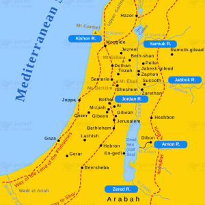
The Northern Coastal Plain in Ancient Israel was a region that stretched along the Mediterranean Sea and extended from the Carmel Mountain Range in the north to the Plain of Sharon in the south. This stock image depicts the ancient cities and towns that were located in this region, including Acre, Tyre, Sidon, and Beirut, among others. The map also shows the important trade routes that passed through this area, connecting the ancient Near East with the Mediterranean world.
The Northern Coastal Plain was a fertile and prosperous region, known for its agriculture, fishing, and maritime trade. The ancient cities and towns in this area were centers of commerce and culture, attracting merchants and travelers from all over the Mediterranean world. The region was also of strategic importance, as it was situated at the crossroads of several major empires, including the Egyptian, Assyrian, Babylonian, Persian, and Greek empires.
One of the notable historical events that occurred in this region was the battle between Pharaoh Necho of Egypt and King Josiah of Judah at Megiddo in 609 BCE. This battle marked the end of the kingdom of Judah and the beginning of the Babylonian exile. The map shows the location of Megiddo and other important sites associated with this event, including the city of Jerusalem and the ancient kingdoms of Egypt and Assyria.