Persian Empire around 475 BC
$20.00
- Description
Description
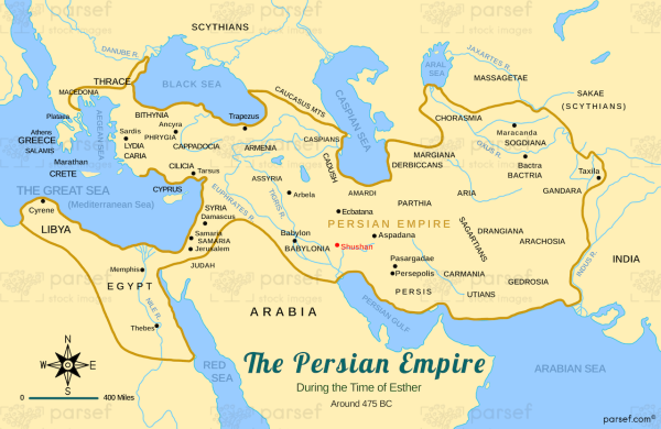
The stock image provides a detailed and accurate representation of the geography and political landscape of the Persian Empire during the reign of the Achaemenid dynasty. The map is a vibrant and colorful display of the vast expanse of the empire, which stretched from the Mediterranean Sea to the Indus River Valley.
The map highlights the major regions and provinces of the empire, including Persis, Elam, Babylonia, Assyria, Media, and Lydia. It also shows the various cities and key points of interest, such as the capital city of Susa, the royal palace at Persepolis, and the legendary city of Babylon.
The map provides insight into the complex political landscape of the Persian Empire, including the relationships between the different provinces, the territories that were subject to tribute, and the areas that were directly under the control of the Persian king. It also shows the major trade routes and travel routes that were central to the functioning of the empire, such as the Royal Road that connected Susa with Sardis.
Overall, the stock image is a valuable resource for anyone interested in exploring the rich history and culture of the ancient Persian Empire. The map provides a vivid and detailed picture of the geography and political landscape of the region during this important period, and offers a unique perspective on the complex interplay between the different regions and provinces of the empire.

