Alexander the Great’s Empire
18,00 €
- Description
Description
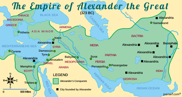
The stock image depicts the vast empire that was conquered and ruled by Alexander the Great, one of the greatest military leaders in history. The map is rendered in a muted color scheme, with major cities and landmarks marked in black.
The map shows the extent of Alexander’s empire, which at its height spanned from modern-day Greece and Egypt in the west to parts of India in the east. The map highlights the major cities of the empire, including Alexandria, the capital city founded by Alexander in Egypt, and Babylon, the center of culture and learning in the empire.
Other important cities such as Athens, Corinth, and Thebes in Greece, and Susa and Persepolis in Persia are also marked on the map. The Tigris and Euphrates rivers, which were important waterways for trade and transportation, are prominently featured on the map as well.
The map also includes important landmarks and battle sites from the time of Alexander’s conquests, such as the battlefield of Issus where Alexander defeated the Persian army, and the temple complex of Siwa in Egypt, where he was declared the son of the god Ammon.
The borders of Alexander’s empire are marked with a thick black line, which distinguishes the territories he conquered and ruled from those that remained independent.
Overall, the stock image provides a detailed and visually engaging representation of the vast territories that were conquered and ruled by one of the most famous conquerors in history. It is a useful resource for historians, educators, and anyone interested in the rich history of the ancient world.

