Assyrian Conquests
18,00 €
- Description
Description
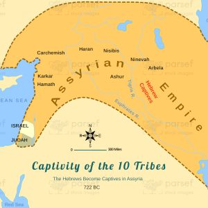
The stock image portrays a historical map depicting the extensive territorial expansions of the ancient Assyrian Empire. The map features various geographic locations, including the Tigris and Euphrates River valleys, Mesopotamia, Anatolia, and the Levant.
The image depicts the vast conquests made by the Assyrians during the 9th to 7th centuries BCE. The empire’s military prowess and strategic prowess are evident in the depiction of their successful campaigns, as they expanded their influence and control over neighboring kingdoms and territories.
The map also includes illustrations of ancient cities, fortifications, and landmarks, providing a visual representation of the extent of the Assyrian Empire’s domination. The colors used in the image, including shades of green, blue, and brown, help to differentiate between different regions and territories, while also highlighting the various conquered territories.
Overall, the stock image offers a unique glimpse into the history and legacy of the ancient Assyrian Empire, showcasing the scale and impact of their conquests on the ancient Near East.