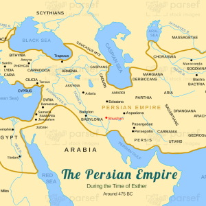
Assyrian Empire Under Esarhaddon
$20.00
- Description
Description
The stock image is a historical depiction of the powerful empire at the height of its dominance in the 7th century BC. The map is designed with a parchment-style background, featuring a detailed representation of the Assyrian kingdom’s vast territory and prominent cities.
The empire, as portrayed on the map, spans from the Mediterranean Sea in the west to the Persian Gulf in the east, and from the Taurus Mountains in the north to the Arabian Peninsula in the south. The map’s boundaries are marked with dotted lines and shaded areas, showing the extent of the Assyrian Empire’s control over neighboring lands.
The map highlights major cities and population centers such as Nineveh, Ashur, and Babylon, the latter of which was one of the most important cities in the empire during the reign of Esarhaddon. The cities are depicted with prominent symbols and bold lettering to indicate their significance to the Assyrian Empire.
The map also features prominent rivers, including the Tigris and Euphrates, which were important to the empire’s trade, agriculture, and military operations. Mountain ranges such as the Zagros and Taurus are also illustrated, as they provided natural barriers that helped define the borders of the empire.
In addition to the geography, the map provides a legend that explains the various symbols and colors used to represent different features of the empire. This includes information on military garrisons, trading routes, and conquered territories.
Overall, the stock image is an informative and visually striking representation of one of the most powerful empires in ancient history, providing a valuable resource for scholars, students, and anyone interested in the history of the Middle East.