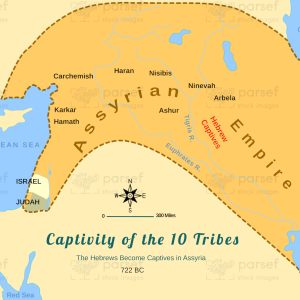
Assyrian Empire Under Sennacherib
18,00 €
- Description
Description
The stock image is a historical map that depicts the Assyrian Empire during the reign of King Sennacherib, who ruled from 704 to 681 BCE. The map features various regions of the ancient Near East, including Mesopotamia, the Levant, and parts of Anatolia.
The image portrays the extent of the Assyrian Empire’s territorial expansion during Sennacherib’s reign, showing the various conquered territories and city-states that were under Assyrian control. The map also displays the different kingdoms and empires that were allied or in conflict with the Assyrians, providing a visual representation of the complex political landscape of the ancient world.
The use of colors in the map, such as shades of green, blue, and brown, helps to differentiate between different regions and territories, while also highlighting the various Assyrian conquests. The map also features illustrations of ancient cities, fortifications, and landmarks, providing a sense of the empire’s cultural and economic significance.
Overall, the stock image offers a fascinating glimpse into the history and legacy of the Assyrian Empire, showcasing the scale and impact of its military and political power on the ancient Near East during one of its most significant periods.