Canaan During the Time of Abraham
18,00 €
- Description
Description
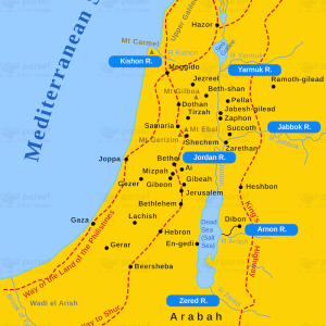
The stock image is a map that depicts the region of Canaan during the time of Abraham, one of the patriarchs of the Hebrew Bible. The map displays the geography and location of the various Canaanite cities and regions that Abraham was said to have visited and lived in.
The map highlights the cities of Shechem, Bethel, Hebron, and Beersheba, which were significant to Abraham’s story in the Bible. The image also shows the regions of the Negev, the hill country of Ephraim, and the Jordan Valley, which Abraham is said to have traveled through.
The map provides context to Abraham’s journey and highlights the challenges he faced in his travels, such as the rugged terrain of the hill country and the harsh desert conditions of the Negev. It also shows the importance of water sources and trade routes in the region, which Abraham would have utilized in his travels.
The image also includes other notable Canaanite cities and regions, such as Jericho, Gaza, and the coastal plain. These locations were significant in the region’s history and culture and would have played a role in Abraham’s interactions with the Canaanite people.
Overall, the image is a visual representation of the region of Canaan during the time of Abraham and provides a glimpse into the challenges and opportunities that he would have faced in his journey. It also highlights the importance of the region’s geography and cultural heritage, which have shaped the history and identity of the people who have lived there for thousands of years.