Canaan Twelve Tribe Portions
18,00 €
- Description
Description
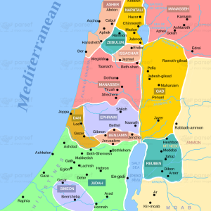
The stock image is a map that depicts the portions of the land of Canaan assigned to the twelve tribes of Israel after their exodus from Egypt. The map displays the geography and location of each tribe’s territory, which was outlined in the Bible’s book of Joshua.
The map highlights the twelve tribes of Israel, including Reuben, Simeon, Judah, Issachar, Zebulun, Dan, Naphtali, Gad, Asher, Ephraim, Manasseh, and Benjamin. Each tribe’s territory is depicted with a distinct color, and the borders of each region are delineated clearly.
The image also includes notable cities and landmarks within the territories of the twelve tribes, such as Jerusalem, Bethlehem, and Mount Gerizim. These locations played significant roles in the biblical narratives and were central to the tribes’ history and culture.
The map provides context to the twelve tribes’ history and journey, from their exodus from Egypt to their conquest and settlement of Canaan. It also highlights the geographical challenges and opportunities that the tribes faced, such as the rugged terrain of the hill country and the fertile valleys of the Jordan River.
Overall, the image is a visual representation of the biblical account of the twelve tribes of Israel’s settlement in Canaan. It provides a glimpse into the history and culture of the Israelites and their relationship with the land of Canaan, which is central to their identity and faith.