David’s Kingdom
$20.00
- Description
Description
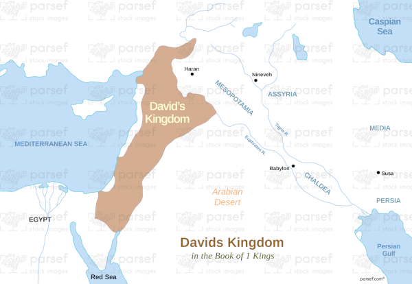
The stock image depicts a map of David’s Kingdom, an ancient empire that existed during biblical times. The map is set against a beige background with black borders and white font to label the various regions and landmarks.
The map shows the geographical boundaries of David’s Kingdom, which covered much of modern-day Israel and parts of Jordan and Syria. The kingdom extended from the Mediterranean Sea in the west to the Jordan River in the east and from the Negev Desert in the south to the hills of Galilee in the north.
Various cities and regions are labeled on the map, such as Jerusalem, Bethlehem, Hebron, and Jericho. Jerusalem, the capital of the kingdom, is marked with a prominent star and is located in the central region of the map.
The image also features illustrations of notable landmarks and structures, including the City of David, the ancient fortress that served as the seat of power for the kingdom. The fortress is shown as a large structure with high walls and towers.
Additionally, the map highlights the strategic importance of the kingdom, as it was located at the crossroads of important trade routes and provided a natural defense against invading armies. This strategic location helped to establish David’s Kingdom as a major power in the region during biblical times.
Overall, this stock image provides a visual representation of the geographical boundaries and strategic importance of David’s Kingdom, highlighting the importance of this ancient empire in the history of the region.


