Divisions of Herod’s Kingdom
18,00 €
- Description
Description
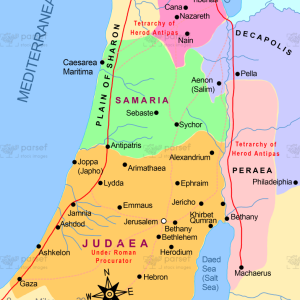
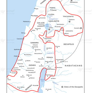
The stock image depicts the territories that were ruled by Herod the Great’s descendants following his death in 4 BCE. The map is rendered in a muted color scheme, with each territory marked in a different color.
The map shows the three main territories that were ruled by Herod’s sons after his death: Archelaus ruled over Judea, Samaria, and Idumea; Herod Antipas ruled over Galilee and Perea; and Philip ruled over the territories to the northeast of the Sea of Galilee.
The map also highlights important ancient cities that were part of each territory, such as Jerusalem, Caesarea, and Tiberias.
Other important sites in the region include the Jordan River, which served as an important boundary between the territories, and the Dead Sea, which was an important source of salt and other minerals.
The map also includes important routes and roads that were used for travel and commerce during this time period, such as the Via Maris and the King’s Highway.
Overall, the stock image provides a detailed and visually engaging representation of the territories that were ruled by Herod’s descendants after his death. It is a useful resource for historians, educators, and anyone interested in the rich history of the region and its political divisions during the time of the Roman Empire.