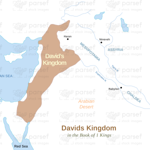
Egypt During Abraham’s Time
18,00 €
- Description
Description
The stock image depicts the geographic region of Egypt during the time of the patriarch Abraham, as described in the Old Testament. The map is rendered in a muted color scheme, with different territories and regions marked in different colors for clarity.
The map shows the region of North Africa that was known as Egypt during the time of Abraham, including the Nile River Valley and the surrounding desert. It highlights the major cities and settlements that were part of Egypt during this period, such as Memphis, Thebes, and Heliopolis.
The map also shows the important routes and roads that were used for trade and commerce in ancient Egypt, such as the Nile River and the Red Sea. It also depicts the different natural features of the region, including the Nile Delta and the Sinai Peninsula.
The map highlights the important role that Egypt played in the ancient world as a center of civilization, culture, and religion. It also shows the different kingdoms and dynasties that ruled over Egypt at various times, including the Old Kingdom and the Middle Kingdom.
Overall, the stock image provides a detailed and visually engaging representation of the geographic region of Egypt during the time of the patriarch Abraham, and is a useful resource for historians, educators, and anyone interested in the rich history and culture of ancient Egypt.