Herod the Great’s Kingdom
17,00 €
- Description
Description
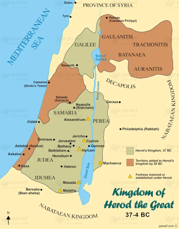
The stock image depicts the territories that were ruled by Herod the Great, a king of Judea who reigned from 37 BCE to 4 BCE. The map is rendered in a muted color scheme, with the territories of Herod’s kingdom marked in black.
The map shows the extent of Herod’s kingdom, which included Judea, Samaria, and Idumea in modern-day Israel and Palestine, as well as portions of modern-day Jordan and Syria. It highlights important ancient cities that were part of Herod’s kingdom, such as Jerusalem, Bethlehem, and Jericho.
The map also shows important landmarks in the region, such as the Dead Sea, which was an important source of salt and other minerals in ancient times, and the Jordan River, which was an important source of water for the region.
Other important sites in the region include the fortress of Masada, which was built by Herod and was the site of a famous siege by the Roman army, and the city of Caesarea Maritima, which was an important center of trade and commerce on the Mediterranean coast.
Overall, the stock image provides a detailed and visually engaging representation of one of the most significant rulers in the history of ancient Judea. It is a useful resource for historians, educators, and anyone interested in the rich history of the region.

