II Chronicles Israel and Judah
18,00 €
- Description
Description
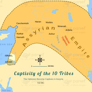
The stock image map for II Chronicles displays the territories of Israel and Judah during the reign of various kings and events from their history. The map illustrates the boundaries of the two kingdoms and the major cities and towns that existed during that time, such as Jerusalem, Bethlehem, Samaria, and Hebron.
The map includes markers indicating key events, such as the reigns of David and Solomon, the construction of the Temple in Jerusalem, the division of the kingdom into Israel and Judah, and the subsequent reigns of the kings in both kingdoms. The map also depicts the territories conquered by the Assyrian Empire and the Babylonian Empire, which led to the exile of the Jewish people.
Overall, the II Chronicles map provides a visual representation of the political and cultural landscape of ancient Israel and Judah and helps to better understand the historical context of the biblical stories and events.