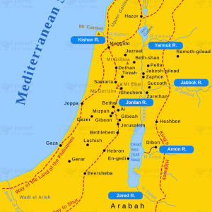
II Kings Samaria and Nearby Lands
18,00 €
- Description
Description
This stock image depicts the city of Samaria and the surrounding lands during the time of the Northern Kingdom of Israel. The map shows the location of Samaria in relation to neighboring regions, including the coastal areas of Tyre and Sidon to the west, the Kingdom of Damascus to the east, and the Jordan River to the east.
The map also shows major cities in the region, including Jezreel, Megiddo, and Beth Shean. In addition, the map indicates the location of several significant sites in biblical history, such as Mount Carmel and the Jezreel Valley.
This map would be useful for illustrating biblical accounts related to the Northern Kingdom of Israel during the time of the kings, as recorded in the book of II Kings.