Israel and Judah
18,00 €
- Description
Description
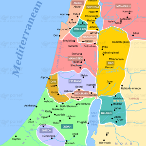
The stock image depicts the historical territories of Israel and Judah during the Iron Age period in the ancient Near East. The map is rendered in a muted color scheme, with the different regions and territories marked in different colors for clarity.
The map shows the region of Israel and Judah, which includes modern-day Israel, Palestine, and parts of Jordan and Syria. It highlights the different kingdoms and empires that controlled the region throughout history, including the Canaanites, Israelites, Assyrians, Babylonians, Persians, and Greeks.
The map also shows the important cities and settlements that were located in Israel and Judah, including Jerusalem, Bethlehem, Samaria, and Nazareth. It highlights the different natural features of the region, including the Jordan River and the Dead Sea.
The division of Israel and Judah is a significant event in the history of the region. The map shows the borders of the two kingdoms, as well as the various battles and conflicts that occurred between them. It also highlights the important prophets and leaders who were associated with the region, such as Elijah, Elisha, and King David.
Overall, the stock image provides a detailed and visually engaging representation of the historical territories of Israel and Judah, and is a useful resource for historians, educators, and anyone interested in the rich history and culture of the region.