Joshua Philistia
18,00 €
- Description
Description
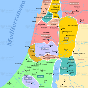
The stock image depicts the region of Philistia during the time of Joshua. Philistia was an area located along the Mediterranean coast, in what is now modern-day Israel and Palestine.
The map shows the various cities and towns that were inhabited by the Philistines, including Ashdod, Ashkelon, Gaza, Ekron, and Gath. The Philistines were a powerful people who posed a significant threat to the Israelites, and the map highlights the strategic importance of the Philistine cities as well as the routes through which the Israelites could attack them.
Overall, the map provides a visual representation of the geographical and political landscape of Philistia during the time of Joshua’s conquest of the Promised Land.