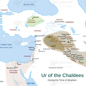
Map of The Assyrian Empire
18,00 €
- Description
Description
The stock image depicts the geographical extent of the Assyrian Empire, one of the most powerful empires of the ancient world. The map is rendered in a muted color scheme, with major cities and landmarks marked in black.
The map shows the vast territory controlled by the Assyrian Empire, which at its height stretched from modern-day Iraq and Iran in the east to parts of Syria, Turkey, and Egypt in the west. The Tigris and Euphrates rivers, which were the lifeblood of the empire, are prominently featured on the map, along with other important waterways and mountain ranges.
The major cities of the empire, including Nineveh, the capital city, and Ashur, the religious and cultural center of the empire, are marked with large black dots, indicating their importance. Other important cities, such as Babylon, Ur, and Damascus, are also marked on the map.
The map also includes important landmarks from the Assyrian period, such as the palace complex of Nimrud and the ancient city of Khorsabad. The borders of the empire are marked with a thick black line, demarcating the extent of Assyrian control during this period of its history.
Overall, the stock image provides a detailed and visually engaging representation of the vast territorial expanse of one of the most powerful empires of the ancient world. It is a useful resource for historians, educators, and anyone interested in the rich history of the Near East.