Land of Ancient Assyria
17,00 €
- Description
Description
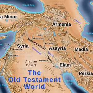
The stock image depicts the Land of Ancient Assyria, an empire that existed in the Mesopotamian region from the 25th century BC until its fall in the late 7th century BC.
The map shows the vast territory of the empire, which extended from modern-day Iran and Iraq to parts of Syria and Turkey. The capital city of the empire, Nineveh, is prominently marked on the map. Other major cities and regions such as Babylon, Nippur, Ashur, and the Tigris and Euphrates rivers are also shown.
The map provides a visual representation of the size and power of the ancient Assyrian empire and the geographic locations of its key centers of civilization.


