Nile River
17,00 €
- Description
Description
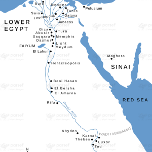
The stock image depicts the longest river in the world, the Nile, which flows through eleven countries in northeastern Africa. The map is designed with detailed lines and colors, indicating the course of the river and the locations of the various cities and landmarks that are situated along its banks.
The map highlights the different sections of the Nile, including the White Nile and the Blue Nile, and shows how the river changes in width and flow as it travels through different regions. It also indicates the various tributaries that feed into the Nile, such as the Atbara River and the Sobat River.
Furthermore, the map provides information on the important historical and cultural sites that are located along the Nile, including the ancient city of Thebes (modern-day Luxor), the Valley of the Kings, and the Aswan Dam. These sites are testament to the significance of the Nile in the development of ancient Egyptian civilization, as the river provided water for irrigation, transportation, and other vital activities.
Overall, the stock image provides a useful tool for those interested in studying the geography, history, and culture of northeastern Africa. It highlights the importance of the Nile as a source of life and vitality for the region, and illustrates the many ways in which the river has shaped the course of human history.


