Assyrian Empire at the Time of Nahum
19,00 €
- Description
Description
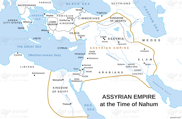
The stock image is a detailed depiction of the ancient Mesopotamian kingdom at its peak. The map is set against a parchment background and features intricate illustrations of the major cities, rivers, and mountain ranges of the region.
The Assyrian Empire, as shown on the map, covers an expansive territory that extends from the Persian Gulf in the east to the Mediterranean Sea in the west, and from the Caucasus Mountains in the north to the Arabian Peninsula in the south. The boundaries of the empire are marked with dotted lines and shaded areas, providing a clear representation of its territorial extent.
The cities of Nineveh, Ashur, and Calah, which were the most prominent centers of power in the Assyrian Empire, are highlighted on the map with bold lettering and distinct symbols. Other major cities such as Arbela, Harran, and Nimrud are also labeled and located on the map.
The Tigris and Euphrates rivers, which were vital to the empire’s agricultural and trade activities, are shown winding their way through the map, while the Zagros and Taurus mountains are depicted in the north and west respectively. The map also features a legend that explains the symbols and colors used to represent various features of the map.
Overall, the stock image is a detailed and accurate representation of the ancient kingdom, providing a valuable visual aid for students, historians, and anyone interested in the history of the Middle East.


