Bodies of Water in Ancient Israel
18,00 €
- Description
Description
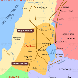
The stock image is a map that depicts the bodies of water in ancient Israel, including lakes, rivers, and seas. The map displays the geography and location of the various bodies of water that were significant in the region’s history and culture.
The map highlights the Sea of Galilee, the Dead Sea, the Jordan River, and the Mediterranean Sea, which were critical to the ancient Israelites’ trade, agriculture, and religious practices. The image also shows the location of smaller bodies of water, such as the Kinneret River and the Huleh Lake.
The map provides context to the ancient Israelites’ relationship with water, which was essential for their survival in the region’s arid climate. The image shows how bodies of water served as natural borders, trade routes, and sources of irrigation for the ancient Israelites.
The image also includes notable locations along the bodies of water, such as Capernaum on the Sea of Galilee, Jericho on the Jordan River, and Masada on the Dead Sea. These locations played significant roles in the ancient Israelites’ history and culture and have left an enduring impact on the region’s heritage.
Overall, the image is a visual representation of the bodies of water in ancient Israel and their significance to the region’s history and culture. It provides a glimpse into the ancient Israelites’ relationship with water and their use of natural resources to thrive in a challenging environment.