Canaanite Nations
$20.00
- Description
Description
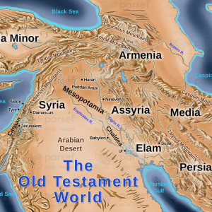
The stock image is a map that depicts the Canaanite nations in the ancient world. The map displays the geography and location of the various Canaanite nations, which were prominent in the region during the Bronze Age.
The Canaanite nations, which include the Ammonites, Moabites, Edomites, and others, are highlighted on the map with distinct colors and labels. The nations are shown in relation to the surrounding regions and borders, including the Mediterranean Sea to the west and the Jordan River to the east.
The map also includes significant cities and landmarks of the Canaanite nations, such as Jerusalem, Jericho, and the Dead Sea. These locations were critical to the Canaanite nations’ trade, religion, and politics, and they played a significant role in the region’s history and development.
The map also provides context to the Canaanite nations’ interactions with neighboring empires, such as Egypt and Mesopotamia. The image shows how the Canaanite nations were situated at the crossroads of various trade routes and were subjected to the influence of these powerful empires.
Overall, the image is a visual representation of the Canaanite nations’ significance in the ancient world, their geographical location, and their relationship with neighboring empires. It provides a glimpse into the history and culture of the Canaanite nations, which have left an enduring impact on the region’s history and development.