David and Solomon’s Empire
19,00 €
- Description
Description
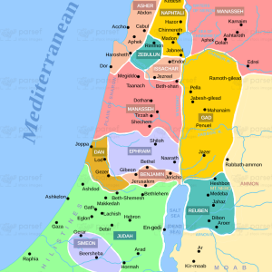
The stock image shows the extent of the Israelite kingdom during the reigns of King David and his son Solomon. The map is set in the ancient Near East and covers the areas of modern-day Israel, Jordan, Lebanon, and parts of Syria and Iraq.
The map highlights key locations such as Jerusalem, the capital city, and other major cities like Hebron, Bethlehem, and Megiddo. It also shows the territories that the Israelites conquered under David’s leadership, including the kingdoms of Moab, Ammon, and Edom.
The image shows the trade routes that connected the Israelite kingdom to the surrounding nations, including the famous King’s Highway, which ran from Egypt to Damascus. The map also depicts the strategic importance of the Jordan River Valley, which served as a natural boundary between the Israelites and their eastern neighbors.
Overall, the map provides a visual representation of the extent and power of the Israelite kingdom during its peak under David and Solomon.