Highways in Old Testament Israel
18,00 €
- Description
Description
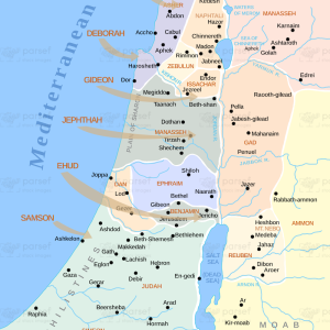
The stock image depicts the major roadways and trade routes of ancient Israel during the time of the Old Testament. The map is rendered in a simple and clear style, with the different roads and routes marked in different colors for clarity.
The map shows the major north-south routes that ran along the Mediterranean coast and through the Jordan Valley, as well as the east-west routes that connected the major cities and regions of Israel. These included the Via Maris, a major trade route that ran along the coast from Egypt to Syria, and the King’s Highway, an important east-west route that ran from Damascus to the Gulf of Aqaba.
The map also shows the various other roads and paths that connected the smaller towns and villages of Israel, as well as the major river crossings and mountain passes that were essential for trade and transportation.
In addition to the roads themselves, the map also highlights the various important cities and landmarks along the way, including Jericho, Bethel, and Jerusalem. It also shows the location of various biblical events and stories that took place along these routes, such as the story of the Good Samaritan.
Overall, the stock image provides a clear and detailed representation of the major roadways and trade routes of ancient Israel, and is a useful resource for historians, educators, and anyone interested in the rich history and culture of the region.


