Judea in the Old Testament
19,00 €
- Description
Description
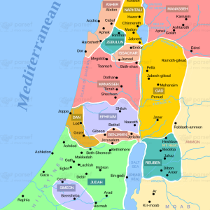
The stock image depicts the region of Judea as it was during the time of the Old Testament. The map shows the boundaries of the region, which extended from the Mediterranean Sea in the west to the Jordan River in the east. The map also displays the major cities in the region, including Jerusalem, Bethlehem, Hebron, and Jericho.
In addition to the cities, the map shows the topography of the region, which is characterized by hills and valleys. The region is also known for its desert areas, particularly in the south. The map also shows the major highways and trade routes that passed through Judea, which made the region an important crossroads of commerce and culture.
The map provides a glimpse into the geography and history of the region as described in the Old Testament. Judea was a significant region in the Bible, playing a central role in the stories of King David, the Babylonian exile, and the life of Jesus Christ. The map helps to contextualize these stories and better understand the geography of the region during biblical times.