Land of Ancient Israel
18,00 €
- Description
Description
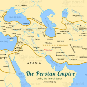
The Land of Ancient Israel was an area of the eastern Mediterranean region that encompassed modern-day Israel, Palestine, Jordan, and Lebanon. This stock image map provides a visual representation of the borders and geography of the region during ancient times. The map highlights the Mediterranean Sea to the west and the Jordan River to the east.
The land is divided into several distinct regions, including Galilee, Samaria, Judea, the Jordan Valley, and the Negev Desert.
The map also includes major cities and towns, such as Jerusalem, Bethlehem, Nazareth, Jericho, and Hebron. Overall, this map offers insight into the ancient world of the Bible and the lands where many biblical stories and events took place.