Map of the Land of Canaanite and the Canaanite Tribes
18,00 €
- Description
Description
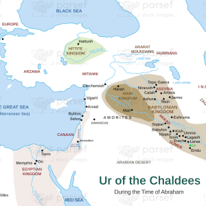
This high-resolution map (300 DPI) offers an in-depth look at the ancient Land of Canaan, showcasing the territories of the Canaanite tribes as described in the Bible and historical records. The land of Canaan, which stretched from the Jordan River to the Mediterranean Sea, was home to various indigenous peoples, including the Hittites, Amorites, Jebusites, Hivites, Perizzites, and Girgashites (Genesis 10:15–19, Exodus 3:8, Joshua 3:10). These tribes played a significant role in biblical narratives, particularly during the time of Abraham (Genesis 12:6–7), the Exodus, and the Israelite conquest led by Joshua (Joshua 1:4, 3:10).
This map highlights key cities such as Jericho, Hebron, and Jerusalem, as well as important geographical landmarks like the Jordan River, the Dead Sea, and the coastal plains of the Mediterranean. The Canaanite civilization, influenced by Mesopotamian and Egyptian cultures, was known for its fortified city-states, advanced trade networks, and religious practices, which often clashed with Israelite monotheism (Deuteronomy 7:1–5).
Designed for scholars, educators, and Bible enthusiasts, this map serves as an essential visual aid for understanding the historical and scriptural significance of Canaan. Whether used for academic study, biblical research, or personal exploration, it brings to life the lands and people who shaped the course of ancient history.