Twelve Tribes of Israel
18,00 €
- Description
Description
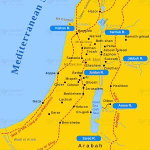
The stock image is a map showcasing the Twelve Tribes of Israel. The map displays the region of ancient Israel with the Jordan River as its eastern boundary and the Mediterranean Sea as its western boundary. The map is divided into twelve sections, each representing one of the twelve tribes of Israel. The names of the tribes are labeled on each section of the map.
The northernmost tribe is Naphtali, followed by Asher, Zebulun, Issachar, Dan, and Manasseh. In the center of the map are Ephraim and Benjamin, and to the south are Simeon, Judah, and Gad. The map also includes major cities and landmarks, such as Jerusalem, the Dead Sea, and the Sea of Galilee.
The map provides a visual representation of the division of the land among the twelve tribes of Israel after the conquest of Canaan. It is a useful resource for those studying the history and geography of ancient Israel.